Filed under: centred/focused
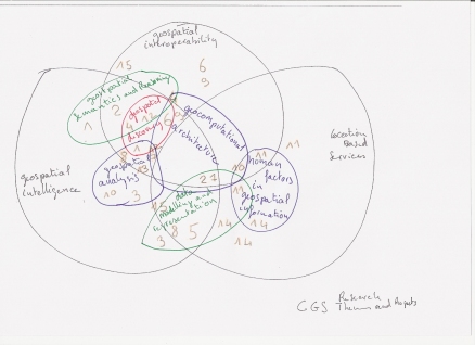
Following a very interesting research discussion, we may be getting closer to coming up with a succinct statement of the scope and focus of the centre’s activities. As a prelude to a statement in words, here is a diagram for discussion. Please add comments, or give feedback on whether you think this is an accurate statement covering what we do.
Filed under: centred/focused
Where does the discipline of geospatial science fit into the broader scheme of the study of science and technology? It is often described as being at the junction of geography and computer science, but what does it take from each field of endeavour? Is it primarily focussed on technology, or is it about geographical theory, or both, or something else entirely? If both, then how do we resolve the tension between the two?
A technology-focussed approach to any field of endeavour is often driven by current societal demands and is time-critical, because technology moves on rapidly. If the research idea is of commercial interest and the research process is too slow, then private commercial organisations will complete the work and overtake research organisations that have limited resources and the need to publish scholarly work.
A theoretical approach has the benefit of providing a more stable and long-term foundation for research activities, and is a better candidate for research projects with limited resources (for example, PhD projects). Not only are such efforts less prone to sudden changes in technology trends and efforts by large, well-resoured organisations, they are more suited to the exercise of classical research methods and approaches for beginning researchers, and develop a set of knowledge and skills with greater longevity. While knowledge and skills that relate to a particular technology will provide useful practical outcomes in the short term, in 5 years time, they are likely to be redundant.
Despite the many benefits of theoretical research, if it is performed for its own sake without reference to real-world requirements and current societal trends, it risks becoming inappropriate, ineffective, irrelevant or unimportant. When I was doing my PhD, I was involved in numerous discussions about how to choose a good research question. A good research question must be both orginal and worthwhile/useful to society. While no-one may ever have measured how many fleas will fit into a football field (and thus the question is original) – the answer to this question is unlikely to provide much benefit to society. However, if we use the fleas to determine how irregularly-shaped objects can be stacked, how large numbers of creatures behave when trapped in a confined space or how space can be conceptualised in non-cartesian and non-uniform ways depending on its content and format, then the research may become both original and worthwhile.
Technology is a means to an end (one of many means), theory can point the way to that end, but the end is to make a better world. This is the yardstick we must apply to all research.
Filed under: centred/focused
Added the 24/08/2007 … I had a go at it (different stages of the picture can be seen on \\\CGSFiles\Didier)
Filed under: centred/focused
Here’s my attempt at a description of what the Centre does (written for an intelligent lay-person):
The Centre for Geospatial Science undertakes high quality, world-class research regarding information about objects and activities on, above or below the surface of the earth, with a particular emphasis on the spatial, locational aspects of such objects and activities (referred to as geospatial information). Objects and activities of interest may include (but are not limited to) physical, environmental, social or economic phenomenon.
The Centre’s research particularly focuses on the sharing and intelligent use of geospatial information. Our long-term vision is of a world in which a range of diverse users from across the globe can share, combine, understand and use each other’s geospatial information readily in order to solve real problems.
Specific areas of current research within the Centre in order to meet this vision include:
1) Research exploring the intelligent interpretation and use of geographic information, including work in semantics and ontologies, natural language processing and reasoning.
2) Research exploring intelligent discovery, data mining and analysis of geospatial (including remotely sensed) information.
3) Research developing technologies that provide infrastructures to underpin the sharing and remote invocation of geographic information by both humans and computers (geospatial interoperability).
4) Research exploring mobile, location-based technologies (for example, hand-held devices) including user interface and human factors issues.
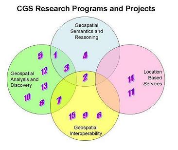
The following diagram depicts current projects in each of these four areas:
- Semantically-aware spatio-temporal analysis (KS).
- Ontological registries (KS).
- Semantically-driven map schematisation (KS, SuA).
- Scientific knowledge infrastructures (KS).
- New methods for map schematisation and generalisation (SuA).
- Interoperability test bed (JS).
- Web service transformations for geospatial processing (JS).
- Multi-scale issues in spatio-temporal analysis (DL).
- Metadata and SDIs (DL).
- Agent-based systems for enhanced decision processes (VK).
- Human factors aspects of navigation (JN).
- Discovery and access of remotely sensed imagery (BP).
- Remote sensing image processing and pattern recognition (PD).
- GUI on hand-held devices for mobile navigation (ShA).
- Conceptual frameworks for SDIs and intelligent data management (SA-S).
Filed under: Uncategorized
A new topic – what do we think the advance of direct mind-to-machine communication will be over the next decade and how will this impact on the social use of mobile communications systems (i.e. network-enabled,mobile phones with indoor-outdoor positioning capabilities?
Filed under: very open general
After the OGCii (Open Geospatial Consortium Interoperability Institute) meeting the 16th of July 2007 at Nottingham ( see the minutes or some report about it probably soon on www.ogcii.org) I wondered if it is possible that the institute would start a “new” discpline?
Filed under: centred/focused
In the process of looking through Mike’s review document, I started to think about the three areas that we work in:
- LBS
- interoperability
- geospatial semantics, cognition, reasoning and discovery.
I thought I’d draw a Venn diagram to see how these all fit together and how all the members of the research team fit into the different research areas (I’ve called them programs) and the overlaps between them. In the process of doing this, I found quite a few projects that didn’t fit anywhere, so I created a fourth area: geospatial analysis and discovery.
Please have a look at this linked web page to see my diagram and list of everyone’s research projects and which programmes they each fit within. Feel free to comment about changes necessary or tell me about any projects that I’ve missed.
Do you think this is an accurate picture of our research?
Filed under: centred/focused
As you are aware, we’ve been having discussions about coming up with a phrase to describe what we do. Some background:
The mystery phrase fits into our CGS description as follows:The top level description of who we are and what we do is in our name: Centre for Geospatial Science. This is a generic description which allows us a lot of room to move and tailor our work to fit in with current changes in technology and trends in geography and information.
We are searching for a second level description that would still be quite generic and avoid specific technologies or methods, but that would give more specific information than the name of the centre. There is some suggestion that the phrase ‘Geospatial Intelligence’ has been used as this second level description in the past, but there are some objections to this phrase, mainly because it has military connotations (for some of us), but most people support the idea of conveying something about our objective being to enable the use of geospatial/geographic information in new, innovative and smarter ways.
There is also a third level description that goes into much more detail about the areas we work in: semantics, LBS, interoperability, remote sensing… This would be expected to change over time (perhaps in the 3 year or so time frame) to reflect changes in trends and technologies. We’ve had some meetings to try to come up with possible phrases. We started looking for a two or three word phrase describing our work. We then considered an alternative goal: to come up with a few words (a bit like a slogan) that describes who we are and what we do. Below I have listed the outcomes of our brainstorming session, including some words, phrases and ideas that were popular – some use the two or three word formula, some are just single words that may trigger ideas, others are entire ‘slogans’.
Please read through the list and comment – feel free to suggest new possibilities, mix and match and combine words on the list in different ways, or register support or lack thereof for any of the listed suggestions.
SO WHAT DO WE REALLY DO? WHAT ARE WE TRYING TO ACHIEVE?
- geospatial awareness
- geospatial consciousness
- geospatial insight
- geospatial exploration
- geospatial discovery
- geospatial understanding
- geospatial reasoning
- geoknowledge
- geocollective
- geospatial diversity
- geospatial perception
- geospatial conception
- geospatial synthesis
- geospatial adaptability
- geospatial enrichment
- achieving insight into geospace
- gaining insight through geospatial interactions
- unlocking the potential of geographic information
- creating insight through geographic information
- creating awareness and knowledge through geographic information
enriching the geospatial experience
…dancing among the geospatial tulips… 🙂
Filed under: very open general
The dreaded phrase that echoes through numerous conferences and publications in the geospatial arena. We recently had a discussion about this in our research discussion series, and responses ranged from benevolent engagement to mild hysteria! So what is special about spatial? Is anything special about spatial? Is this even a useful question?
For my part, I’m not sure that it is a useful question. There’s something special about every field of endeavour, otherwise it wouldn’t be distinct from anything else. But the things that are special about spatial are no more important in nature or magnitude than the things are that special in other fields (say biology, medicine or sociology).
Of course there are things that are different about spatial information (I also don’t like that the question omits a noun, but no doubt I’m just being over pedantic), but I’ll give some other people a chance to speak before I go into that…


